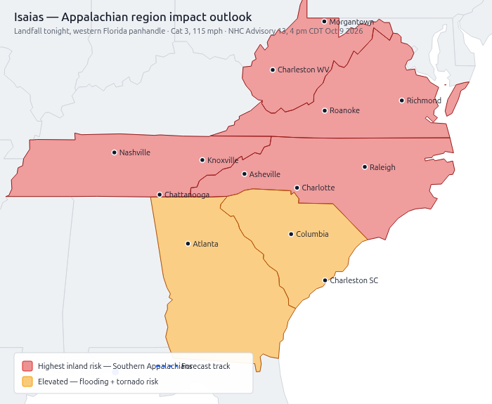
Bottom line: Hurricane Isaias is making landfall on the Florida Panhandle tonight as a Category 3 storm and will drive inland across the Deep South and Southern Appalachians through the weekend. Every state in our region will see impacts. If you are scheduled to game this weekend, plan for disruption.
(Note: this is the 2026 Isaias — not the 2020 storm of the same name.)
Storm snapshot
From the National Hurricane Center’s (NHC) latest advisory:
- Category 3 on the Saffir–Simpson scale — meaning sustained winds of 111–129 mph, a “major” hurricane. Currently 115 mph.
- Landfall tonight near the western Florida Panhandle; track runs north across Alabama into the Tennessee Valley (Sat–Sun), then recurves northeast.
- Rainfall: 2–5 inches region-wide, with localized totals up to 10 inches in the Southern Appalachians and coastal Carolinas.
- Hazards: flash, urban, and river flooding; landslides in the Southern Appalachians; and a tornado risk across the Southeast (detailed below).
Timeline for our region
| Window | Threat |
|---|---|
| Fri night | Tornado risk in south Georgia; storms spread overnight |
| Saturday | Tornado risk (SPC Level 2, “scattered severe storms”) across Georgia and the Carolinas. Tropical tornadoes are often weak, brief, and rain-wrapped — and they strike fast. Know your shelter and keep phone alerts on. Heavy rain begins in the mountains. |
| Sat night–Sunday | Peak inland rain in the Southern Appalachians — flash flooding and landslides. Tornado risk shifts to South Carolina, North Carolina, and southern Virginia. |
| Sun–Mon | Rain pushes through Virginia and West Virginia; river flooding may linger into midweek. |
What the alerts mean
- A Watch means get ready. Conditions are possible, usually hours out.
- A Warning means act now. It’s happening or imminent — take shelter. This applies to tornadoes, flash floods, and severe thunderstorms alike.
- Never drive through flooded roads. “Turn around, don’t drown.” Six inches of moving water can knock you down; two feet can float a car. Mountain routes (the I-40, I-26, and US-23 corridors) are landslide-prone.
Guidance for players and organizers
- Assume weekend games may cancel. Check with your VO/Venture-Captain and the venue before you travel.
- Charge everything now — phones, power banks, and whatever else you need. Power outages are likely.
- Organizers: postpone rather than cancel where you can, update the event on Warhorn, and reschedule tables for the following weekend.
- VOs: report local closures and cancellations up to me so we can track region-wide impact.
Weather terms, decoded
- NHC / NOAA — National Hurricane Center / National Oceanic and Atmospheric Administration; the federal agencies issuing storm forecasts.
- NWS — National Weather Service; your local office issues the watches and warnings for your county.
- Category 1–5 (Saffir–Simpson) — hurricane strength by wind speed. Cat 3 and above is a “major” hurricane. Isaias is Cat 3.
- Tornado risk level 1–5 — from the Storm Prediction Center. 1 = isolated, 5 = outbreak. Level 2 (“Slight”) = scattered severe storms; still dangerous, especially at night.
- Tornado Watch vs. Warning — Watch = get ready. Warning = act now, take shelter.
- Flash Flood Watch vs. Warning — Watch = flooding possible. Warning = flooding happening or imminent.
- Storm surge — ocean water pushed inland by the storm; the leading killer in coastal landfalls.
- Turn around, don’t drown — the standing rule for flooded roads.
Official resources
- NOAA Isaias hub: https://www.noaa.gov/isaias
- National Hurricane Center: https://www.nhc.noaa.gov/
- Local forecasts: https://www.weather.gov/ — find your office (Peachtree City GA; Greenville-Spartanburg and Raleigh NC; Columbia and Charleston SC; Nashville and Morristown TN; Blacksburg and Wakefield VA; Charleston WV)
- Prep checklist: https://www.ready.gov/hurricanes
Risk levels are probabilities, not guarantees. A Watch means get ready; a Warning means act now.
Stay safe, Pathfinders and Starfinders. Report in when you can.